


Painted dish for high-tech link
 Print
Print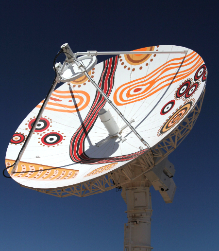 Indigenous artwork has been painted on one of Australia’s most important new satellite antennas.
The upgraded Alice Springs antenna was officially commissioned this week, in a ceremony highlighting both the antenna’s key role in the United States Landsat program, and the artwork painted on its surface that recognises the Arrernte people as traditional owners of the land.
“In 1979 Alice Springs was chosen to host the Landsat Ground Station because of its position in the centre of Australia. Some 37 years on, the antenna is still receiving critical data from international satellites, and with this $4 million upgrade it can now send commands to US Landsat satellites, making it one of only three in the world with this capability,” said Geoscience Australia CEO Dr Chris Pigram said.
“The size of the continent means Australian communities rely on satellite imagery for a range of critical tasks; it is used to respond to natural disasters, monitor land use, develop agriculture and ensure our water security.”
Aboriginal not for profit company, CAT, project managed the antenna’s upgrade, which according to CAT’s Chairman, Peter Renehan, was a natural transition.
“We’ve built a very strong relationship with Geoscience Australia and I think what this project can show to the rest of Australia is that professional, locally-based Aboriginal organisations are capable and you can get these outcomes,” Peter Renehan said.
Arrernte artist, Roseanne Kemarre Ellis created the artwork and helped adapt it to apply to the antenna.
“For me what ties this project together is that Aboriginal art is like a depiction of the land and Aboriginal people do have an aerial view when they paint their art, when they're talking about their country and what it means to them. So there is a connection to the art and the satellite imagery,” Peter Renehan said.
“Having the artwork on the antenna means a lot to Aboriginal people here in Alice, particularly our Board and the Council of Batchelor Institute and the other like-minded organisations on the site. It's a stamp for us to say this is Aboriginal country.”
The artwork, Caterpillar Tracks, highlights the link between the Arrernte people's mapping of their land, and the role of the antenna in collecting satellite imagery of the Earth.
In the Arrernte Aboriginal people's creation story, the Alice Springs region was created by giant caterpillars. These creatures become the ridges of the East and West MacDonnell Ranges that shelter the town of Mparntwe (Alice Springs).
This painting shows the landscape and describes the location of bush tucker, hunting grounds, water holes, travelling routes and other features.
The antenna was formally commissioned this week by Minister for Resources and Northern Australia Matt Canavan, who recognised the important role of the facility in supporting international satellite programs since its construction.
More information is available here, and in the videos below.